
Upcoming: Annual Wallingford Waterway Walk — Sunday, June 14, 2026
Join us for our annual Wallingford Waterway Walk — a guided tour of the string of waterways and street-ends along the north shore of Lake Union, including Waterway 20. All are welcome.
- When: Sunday, June 14, 2026 · 2:00 PM (about 1 hour)
- Where: Meet at the Wallingford Steps (south end of Wallingford Ave N, across from Gas Works Park)
- After: Optional happy hour at Ivar’s Salmon House
- Catch up on the WW20 meetings: View the April 8 community presentation · View the May 26 community presentation (PDF)
Committee Chair: Ted Hunter
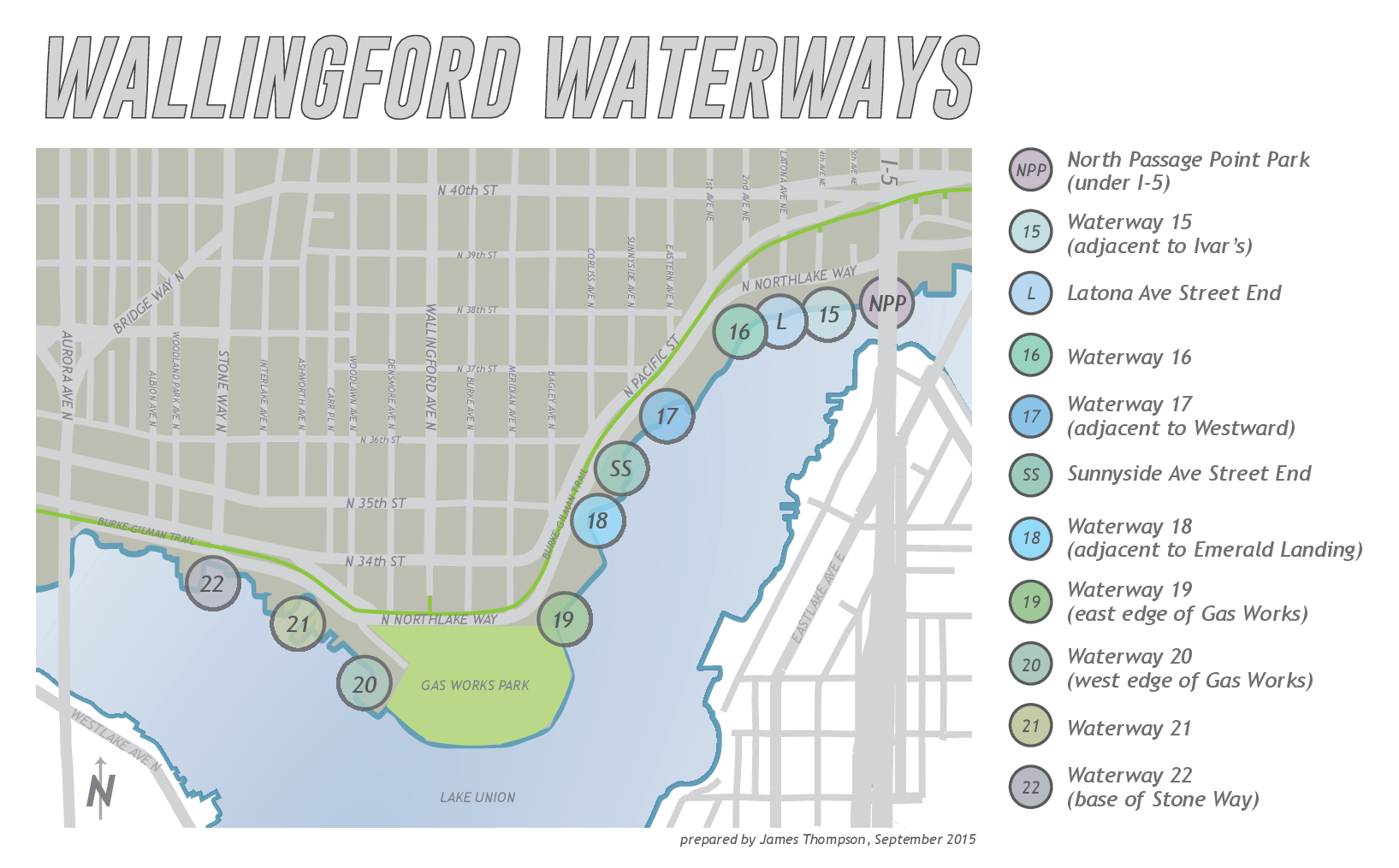
The Wallingford shores of Lake Union
Protecting the shoreline habitat and restoring public access to Lake Union along its shoreline is a top initiative of the Wallingford Community Council. We work with members of the community and different entities on the nine waterways and street-ends along the north shore.
Help us restore Waterway 20 for the public and environment
Join our team to help create an amazing access point at Waterway 20, located just west of the Gas Works Park, for kayakers, paddle boarders, and others who want to enjoy Lake Union.
Today, the Department of Natural Resources (DNR) owns and controls the land where Waterway 20 is located. But, in 2015, the Harbor Patrol blocked public access to the waterway when it expanded the fence for its own property.
Recently, in December 2020, the City of Seattle and DNR signed a lease and have begun working with the WCC to plan for how to both reopen the waterway to the public, as well as share it with the Harbor Patrol. This is great news! And where the work and community involvement, begins.
Want to help expand public access to Lake Union? Take the Waterway 20 Survey to share your ideas for increasing green space and recreational waterfront access. Your voice helps shape how WCC’s state grant for expanding Lake Union access moves forward.
Why are our waterways and street-ends important?
Lake Union is a pre-existing natural lake formed by Vashon Glacier during the last ice age, about 12,000 years ago. Once inhabited by the Duwamish people, today it has a functioning ecosystem with some of the most diverse traffic – from boating/kayaking and boat houses, to tour boats and seaplanes – in the middle of a booming city.
Once upon a time, though, Lake Union had 23 waterways open to the public; now only 18 remain open. Of these, nine are located in Wallingford along the lake’s north shore – Waterways 15-23. Many of these public access points have been slowly turned into private access points or are occupied by city or state government organizations. The WCC was successful over the past two years to keep Waterway 23 open to the public in an agreement with the Lake Washington Rowing Club.
Resources
View and Share the Waterway 20 Public Meeting Presentation — from the 4/8/26 community kickoff at Gas Works Brewing
View and Share the Waterway 20 Public Meeting Presentation — from the 5/26/26 community meeting at Ivar’s Salmon House
Help Shape the Future of Waterway 20 — Take the Community Survey
WA State Ecology: What’s In My Neighborhood — lookup tool that maps contamination cleanup sites across Washington state
Sign up for Ecology updates on Waterway 20
Seattle Police Have Occupied a Public Waterway for Decades — Cascade PBS, 2020
Cheshiahud Loop Trail (Info & Map) — a 6-mile route connecting more than 35 parks, neighborhoods, street ends and waterways that ring Lake Union
Recent Posts
- WCC June 3 Meeting Reminder — Comp Plan Update & Two Bills to Watch
- Help Shape the Future of Waterway 20 — Take the Community Survey
- This Wednesday: Waterway 20 Kickoff at Gasworks Brewing — Help Reopen Lake Union Access
- WATERWAYS WALK – this Saturday! 10am, May 31st, 2025
- Annual Membership Meeting w/ Special Guest Jorge Baron (District 4), Waterways Walk, Gasworks Park News, and Historic Wallingford at Wally-Home Resource Fair
- Monthly Meeting – October 2024
- The Great Wallingford Cleanup – Autumn 2023
- Wallingford Waterway Walk and Tour, 2023
- JOIN US
- Join Us for our Monthly Meeting, Wednesday March 3