
| Wallingford Community Council Meeting Date: Wednesday, February 12, 2025 Time: 7:00 PM – 9:00 PM Location: Room 202, Good Shepherd Center (4659 Sunnyside Ave. N.) Join us on February 12 for the first WCC meeting of 2025, featuring District 4 Council member Maritza Rivera. We’ll discuss the latest updates on the Comprehensive Plan and zoning changes and their impact on Wallingford. With the Final Environmental Impact Study (FEIS) just released and a short window for public input, this is a critical time to stay informed and engaged. Key upcoming meetings and public hearings will shape the future of our neighborhood—get involved! Maritza is a representative of the “One Seattle Team,” and this is a critical opportunity to hear about and discuss the impacts/mitigations identified resulting from the Comprehensive Plan updates and zoning proposals for Wallingford. Maritza can review her role on the Select Committee as she and the full council review the One Seattle Zoning plans and Comprehensive Plan legislation with a public process. (The Select Comm for 2044.) Mark your calendar, bring your questions, and provide feedback to shape the future of our community. BREAKING NEWS: The FEIS (Final Environmental Impact Study) was released yesterday, Jan 30, 2025. There is only a two-week appeal period that closes on Feb 13th, 2025. This document is 1,300 pages and available for reading here: https://www.seattle.gov/opcd/one-seattle-plan?utm_medium=email&utm_source=govdelivery We recommend reading the talking points about the impacts of rezoning for upcoming Select Committee meetings and public hearings on the Comprehensive Plan 2044 Wallingford Community Council’s “One Seattle Plan-Call to Action” |
| Key Topic for 2025: The City Council/Select Committee now focuses on the Public Process for the Comp Plan 2044 and Re-zoning Legislation. The City Council’s Select Committee launched discussions on Jan. 6 on the 2044 Comprehensive Plan and the One Seattle Plan. The “Select Committee” is comprised of all nine City Council staff members. They are responsible for final decisions on the Comp Plan legislation, the HB1110 Middle Housing state mandate passed in 2023, and the Mayor’s additional rezone map proposals. We are including the Select Committee meeting dates and times for people to participate in the public process for Phase 1 legislation through May 2025. The state deadline for the city to complete adoption legislation for HB1110 is June. All Select Committee meetings can be seen live at the time of the meeting or recordings are made available on the Seattle Channel shortly after the meeting ends. (Link: https://www.seattlechannel.org/mayor-and-council/city-council/select-committee-on-the-comprehensive-plan) Upcoming “Select Committee” Meetings. (located at City Hall 600 4th Street Floor 2) – Wednesday, February 5 at 11 am – “Public Engagement” – Wednesday, February 5th at 5:00 pm – “Public Hearing”.Pre-register to be able to make public comments either in person or remotely by signing up here. – Email: council@seattle.gov. Refer here for the full City Council Select Committee Schedule. Only two more Public Hearings are planned through May!  Please review the Wallingford Community Council’s “One Seattle Plan-Call to Action” page for more details and talking points. Past “Select Committee” Meetings: Here is the link to a Seattle Times article with quotes from the council from the first Select Committee meeting on: – Jan. 6: “Comprehensive Plan” Overview: https://www.seattletimes.com/seattle-news/politics/fault lines-emerge-as-seattle-council-takes-up-housing-plan – Jan. 15: “Growth Strategy Overview & Phase 1 Zoning Preview” – Jan. 29: “Select Committee key Topic ‘Displacement’”You can watch recordings and find the presentation slides for the Jan. 6th, 15th, and 29th meetings here: https://www.seattlechannel.org/mayor-and-council/city-council/select-committee-on-the-comprehensive-plan. Future “Select Committee” Meetings: The Select Committee has announced tentative dates for future meetings in March, April, and May. – Wednesday, March 5th – “Comp Plan Issue ID Part I” – Wednesday, March 19th – “Comp Plan Issue ID Part II”April 2,16,( April 30 Public Hearing Comp Plan and Zoning) – May 16 Public Hearing, May 22,23 – May 29th – Final Vote on Phase I – Meeting the state requirements for HB1110 – June to Sept – “Phase 2 zoning legislation” Other Resources: Zoning Proposal Maps: https://one-seattle-plan-zoning-implementation-seattlecitygis.hub.arcgis.com/ OPCD Project Documents / Mayor’s Recommended Growth Strategy (2024). This contains the Draft Plan and other key related documents. Recapping the WCC November / December Meeting Information on One Seattle Plan and Rezone Maps On October 16, 2024, the city released online maps with the locations of “NR” (Neighborhood Residential) zones where formerly single-family lots outside urban villages will be converted to denser multi-family 5,000 square foot lots allowing 4-6 units per lot as required in the state-mandated legislation HB1110. Four units are now allowed in all designated NR zones, but six units are allowed ¼ mile from major transit (rapid ride or light rail). OPCD provided opportunities to comment on online maps using social media and held open houses for each city council district, distributed paper maps for neighborhoods, and closed public comment on December 2024. At our meetings, we demonstrated in our meeting how you can use the online maps to show current and proposed zoning for individual properties by address. We also distributed maps showing proposed rezone locations and differences in the lowrise and NR zones including heights, setbacks, far, lot coverage for each of the zone changes. WCC’s November presentation explained the details of the Mayor’s plan which is additional and separate from the state plan. The Mayor’s rezone proposals include expansions of 30 Neighborhood Centers and conversions of thousands of single-family lots to multi-family surrounding the 30 Neighborhood Centers citywide increasing bulk, height, and scale. In addition, the Mayor’s proposal proposes to rezone single-family lots facing arterials city-wide on the bus routes for “frequent transit” from “single-family lowrise” to 5 stories. The public comments received on the rezone maps through December 20 will be compiled and shared this coming spring 2025. The Comp Plan housing growth target from April 2024 set a target of 80,000 to 120,000 housing units. The FEIS ( Final Environmental Impact Study) just released studied the 80k to 120k impacts for that housing growth target. The Mayor’s plan released on Oct. 16, 2024, surpasses the Comp Plan housing growth target by increasing housing unit growth to 330,000 housing units. The public comments during the Select Committee hearings for the next several months will be considered before the second set of rezone maps are prepared by OPCD and released in May 2025. The vote on revised maps will follow. Michael Hubner, Director for the Comp Plan said “he guarantees there will be changes on the revisions of rezone maps. Major Wallingford Impacts Ask the city to reduce heights in the Mayor’s frequent transit plan from “Lowrise 3” 5-story/50-foot buildings to more compatible heights of “NR” (4-6 units per lot 30 height) or “Lowrise 1” (30 feet) along arterials in Wallingford of routes 62, 31, 32.Let us consider the residents who want to stay in their neighborhoods and the potential displacement here. Many blocks of the formerly single-family zoned lots located along these bus routes in Wallingford have naturally affordable older homes. Many homes are family-sized rentals, including duplexes, triplexes, small apartments, and businesses. The Mayor’s plan is proposing city-wide upzoning on all “frequent transit “arterial facing streets encouraging demolitions, not rehabilitation. These proposed high unit capacity zone proposals at LR3 allow 5-story/50-foot buildings to offer more built-in profitability for developers and will likely accelerate demolitions. This can displace and force out occupants of all ages, races, and incomes who reside in these homes facing arterials citywide. Rezoning for greater unit capacity and jumping to the highest residential zones can increase land values and property taxes for homeowners, renters, businesses, and those on fixed incomes who simply can not keep up with these increases. Assessors base property values on market sales on “highest and best use”. That means you can have property tax increased on the rezoned potential capacity of your lot even though you choose not to redevelop it. The 5-story city-wide plan for rezones citywide along “frequent transit” bus routes…. – Lack of nuances of various neighborhood street considerations – Ignore direct outreach by the city to neighborhoods – Lack of consideration of context and existing heights – Create corridor and canyon effects – Shadow neighboring homes – Devalue investments in solar panels – Reduce access to air and light – Create a loss of trees with an increase in lot coverage from 35% -50%. – Decrease front setbacks for larger tree retention and planting – Create a scarcity of amenities like parks, libraries, and grocery stores for increased populations. – Lack of mitigations for traffic, and parking congestion – and overall is a very weak plan for truly affordable housing A win/win can be achieved with either an NR designation (Hb 1110 4-6 units per 5,000 sq. foot lot) or a Lowrise One zoning designation both blending in with existing heights of 30-foot maximum in the context of older neighborhoods instead of such a height jump to 50 feet to large 5 story buildings on the bus route arterials described below. NR zones 4-6 units per lot or Lowrise one zones increase unit housing capacity and density at heights, but are more compatible with the existing context of these blocks. Ask the council about revisiting and implementing impact fees for parks, fire, schools roads instead of more levies which could help reduce property taxes. Many other municipalities outside of Seattle collect impact fees for infrastructure. Ask for reduced heights from LR3 /5 story /50 feet zoning proposed to NR or LR One /3 story/ 30 feet zoning for residents of these specific streets impacts for arterials on Wallingford bus routes 62, 31,32. 1. Route 62 proposes to upzone properties to Lowrise LR3/5 stories, 50-foot buildings along Meridian north/south from 50th- 56th 2. Routes 31 & 32 propose to upzone properties to LR 3 5 stories, 50-foot buildings along 40th east/west from UW to Wallingford 3. Routes 31 & 32 arrive at the 40th and Wallingford intersection then travel south on Wallingford to 35th 4. Routes 31 & 32 at 35th and Wallingford intersection the bus travels west/east to Fremont Ave. |
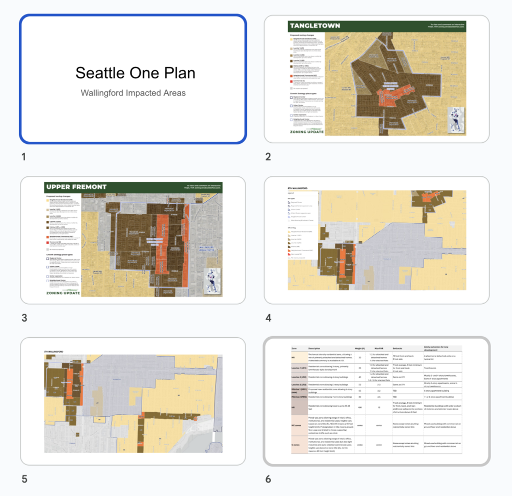
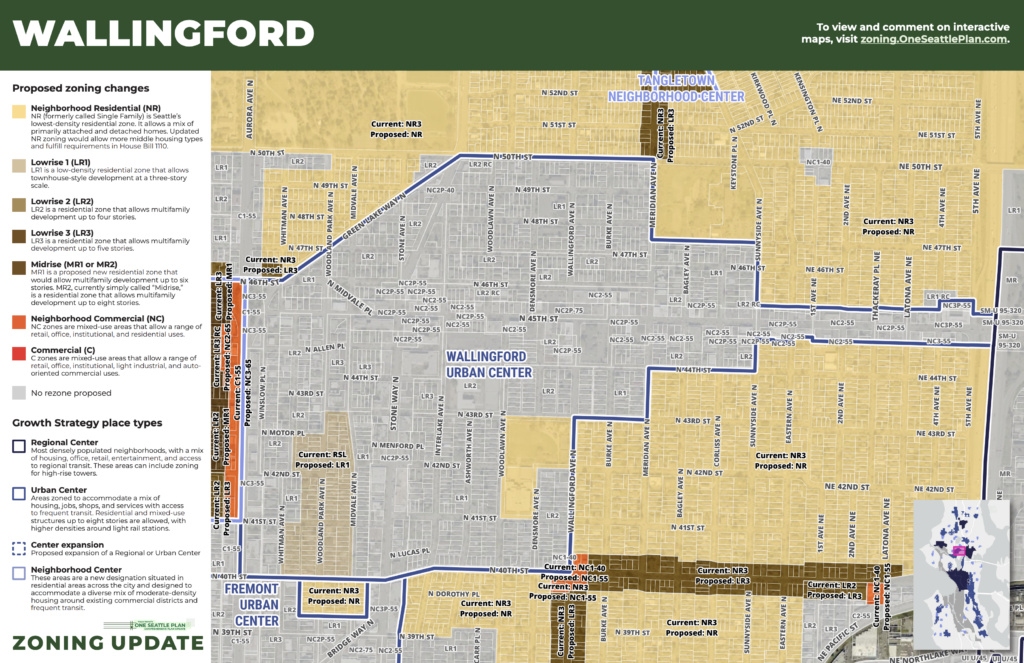
Email all city council: at council@seattle.gov or contact them directly by phone with your concerns.
- Bruce.Harrell@seattle.govOneSeattlePlan.zoning@seattle.gov
- Joy Hollingsworth D3 Chair Select Committee Joy.Hollingsworth@seattle.gov 206 684 8803
- Dan Strauss D6 Vice Chair – North of 50th Wallingford/Tangletown Dan.Strauss@seattle.gov 206 684 8806
- Maritza Rivera D4 Northeast Seattle Wallingford Maritza.Rivera@seattle.gov 206 684 8804
- Sara Nelson At Large Sara.Nelson@seattle.gov 206 684 8809
- Alexis Mercedez Rinck At Large AlexisMercedez.Rink@seattle.gov 206 684 8808
- Robert Kettle D7 Robert.Kettle@seattle.gov 206 684 8807
- Cathy Moore D5 Cathy.Moore@seattle.gov 206 684 8805
- Rob Saka D1 Rob.Saka@seattle.gov 206 684 8801
- Mark Soloman D2 Mark.Soloman@seattle.gov
Thank you for your ongoing support and commitment to making Wallingford a thriving community. Our goal is to update you on the Select Committee meetings and public hearing dates so you can be a part of the public process before final maps and policies for the Comp Plan 2044 are voted on in 2025.
Warm regards,
The Wallingford Community Council
Visit our website | Contact Us