
Join us on a family-friendly walk along Lake Union to learn about the public access points on Lake Union.
When: 9:00 – 11:00 AM on Saturday May 11, 2019. Rain or shine.
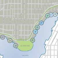
Where: Waterway 15 (Next to Ivar’s on the west, NE Northlake Way & 4th Ave NE). We’ll meet down at the lake by the wooden bench. At about 9:15 AM, we’ll begin to work our way west toward Waterway 22 (the south end of Stone Way). For those so inclined, join us after the walk for a beer at the Fremont Brewery.
Why: Wallingford’s public waterways are wonderful features of our community and the Wallingford Community Council has, through the years, made access to the public waterways a key action item. We hold this walk to raise awareness of where the public access points are along the Wallingford section of Lake Union and to teach some of the history. In addition, we want to improve shoreline habitats.
What: We will visit each Waterway of Wallingford, explaining efforts to preserve public access and showing where they are. If you are handy with the phone and social media – help us to raise awareness of each Waterway on google and apple maps and other social sites with your photos and comments
Preserving Wallingford’s public waterways: These spots along the lake, provide the public (we, the people) opportunities for contemplative scenic views and to watch wildlife (otters, herons, ducks and more) and people life (boaters, seaplanes, and more), restoration of healthy habitats for native fauna and flora, and places to hand launch non-motorized watercraft (kayaks, canoes, and SUPs). They provide stopover points for bicyclists, runners, and walkers using the Burke-Gilman Trail. In the future, it would be lovely to have places to swim, along with beaches for picnics.
RSVPs are helpful but not necessary: communications@wallingford.org. Can’t make it? That’s okay,you can use this map to find the public access points to the water.